

Wrong Turn Almost Sent Me Up the Wrong Mountain: Missouri Mountain and a Clear Creek Dispersed Campsite
Wrong Turn Almost Sent Me Up the Wrong Mountain: Missouri Mountain and a Clear Creek Dispersed Campsite
Missouri Mountain gave me a little bit of everything: a great creekside campsite, steep switchbacks that got my calves complaining immediately, incredible alpine views, and one wrong turn that had me heading toward Mount Belford instead.
Thankfully, I caught that mistake before it became a much bigger problem. The important lesson? At the Belford junction, the route toward Missouri Mountain follows the sign for Elkhead Pass. I was expecting a sign with my mountain’s name on it, and that expectation cost me some extra hiking.
Even with the detour, this was a good trip. Camping just a few minutes from Missouri Gulch Trailhead made the morning easier, and the climb delivered plenty of rewards between the tough sections.
Table of Contents
- Key Takeaways
- Driving County Road 390 to Missouri Gulch
- A Dispersed Campsite Beside Clear Creek
- Missouri Gulch Trailhead: Parking, Facilities, and Route Information
- The Opening Switchbacks Don’t Ease You In
- Breaking Out of the Trees Into Missouri Gulch
- The Wrong Turn: Follow Elkhead Pass at the Belford Junction
- Through the Meadow and Up to the Saddle
- The Ridgeline Still Has Work Left
- Missouri Mountain Summit: Tough Climbs, Worthwhile Rewards
Key Takeaways
- The planned Missouri Mountain hike covers about 10.5 miles with 4,500 feet of elevation gain.
- At the Belford junction, follow the Elkhead Pass branch for the Missouri Mountain route.
- Sunday afternoon arrivals can still find occupied dispersed campsites near Missouri Gulch Trailhead.
- Steep opening switchbacks, the ridge climb, and loose footing near the notch require attention.
Driving County Road 390 to Missouri Gulch
I turned onto County Road 390 on Sunday afternoon with a simple plan: find a dispersed campsite, relax for the evening, and climb Missouri Mountain the following morning.
Passing Clear Creek Reservoir was a rough start. There was still some water, but the exposed reservoir bed was huge. Man, it was sad to see it that low. It had me hoping for a much wetter fall and a snowier winter.
I also noticed signs for a fire camp. I wasn’t sure whether it was a staging area for crews fighting nearby fires, but between those signs and the low water, the dry conditions were hard to ignore.
County Road 390 is a useful access corridor for several Colorado 14ers, including Missouri Mountain, Mount Belford, Mount Oxford, and Huron Peak. I had already been up this road for Huron, which is one of my favorite 14ers. My Huron Peak trip is another option if you’re looking at hikes in the area.
On this drive, the road was bumpy but relatively well maintained. It didn’t feel like a route that required a hardcore off-road vehicle. That accessibility also helps explain why the area is so popular with camper vans and other camping setups.
A Sunday arrival didn’t mean empty campsites
I hoped the Friday and Saturday crowd would have packed up and headed home by the time I arrived. On my previous Huron trip, I had marked several dispersed campsites near Missouri Gulch Trailhead, so I had a few possibilities in mind.
That plan looked less promising as I got closer. Nearly every spot I passed had people in it, and the sites I wanted most, the ones closest to the trailhead, were taken.
I drove up to the trailhead, turned around, and checked a pull-off with several dispersed sites grouped together. It wasn’t quite the secluded spot I had pictured, but I found one large enough for my setup. Sometimes the backup works out pretty well.
A Dispersed Campsite Beside Clear Creek
The campsite I settled on was only a few minutes from the trailhead, reasonably level, and a good size. There appeared to be enough room for a couple of vehicles and a couple of tents.
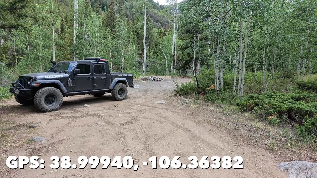
There were neighboring sites nearby, so this wasn’t total solitude. Still, having Clear Creek right below camp was a big plus.
A short path led down to the water, where I found a flat, dry area that would work nicely for a couple of chairs. That’s the kind of campsite feature I appreciate: somewhere to sit back, relax, and listen to the creek before a big hiking day.
The site had an existing stone fire ring, but I left it alone. With all the fires that season, I wasn’t interested in having a campfire.
For dinner, I had a new camp meal to try, teriyaki chicken and rice, along with a few beers for the evening. Nothing complicated. Just get settled, enjoy being out there, and be ready to go first thing in the morning.
Missouri Gulch Trailhead: Parking, Facilities, and Route Information
Missouri Gulch has a decent-sized parking area, but don’t let that fool you into thinking parking will always be easy. The afternoon before my hike, cars were already parked along the road outside the lot.
The trailhead serves more than just Missouri Mountain. Belford and Oxford bring plenty of people here too, and I’ve seen this road lined with cars on busy weekends. The earlier you arrive, the better.
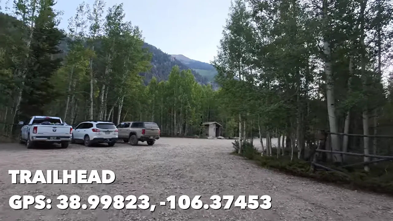
There was one vault toilet. I like to give trailhead bathrooms a rating when they have them, and this one earned a two out of five on my visit. The building itself was fine, but someone had left the interior in pretty unpleasant shape. A cleaning would have made a big difference. I didn’t investigate the mystery liquid, and I’m happy with that decision.
The information boards were another thing worth noticing. They showed route information for Mount Belford and Mount Oxford, but I didn’t find much specific guidance for Missouri Mountain. That made having my own route information especially useful later.
Missouri Mountain hike basics
The route information I used from 14ers.com put the hike at approximately:
- Round-trip distance: 10.5 miles
- Elevation gain: 4,500 feet
- Starting point: Missouri Gulch Trailhead
- Main physical challenges: the opening forest switchbacks and the later climb toward the ridge
Those numbers were for the planned route, not the bonus distance I added by taking the wrong turn.
The Opening Switchbacks Don’t Ease You In
I knew the trail was supposed to start steeply. Knowing that and actually hiking it are two different things.
Missouri Gulch gets right to work with a series of switchbacks through the forest. Of the 14ers I had done up to that point, this felt like the steepest start straight out of the gate.
My body was still warming up, and my calves were already questioning my choices. When the trail finally flattened a little, I stopped for a break and took advantage of the easier walking to recover.
The forest section also included a creek crossing on a narrow bridge made from logs. It looked a little rickety as I approached, but it felt solid when I crossed it. That was my experience that day, not a guarantee about its condition on another trip.
A fire restriction sign and some wildlife nerves
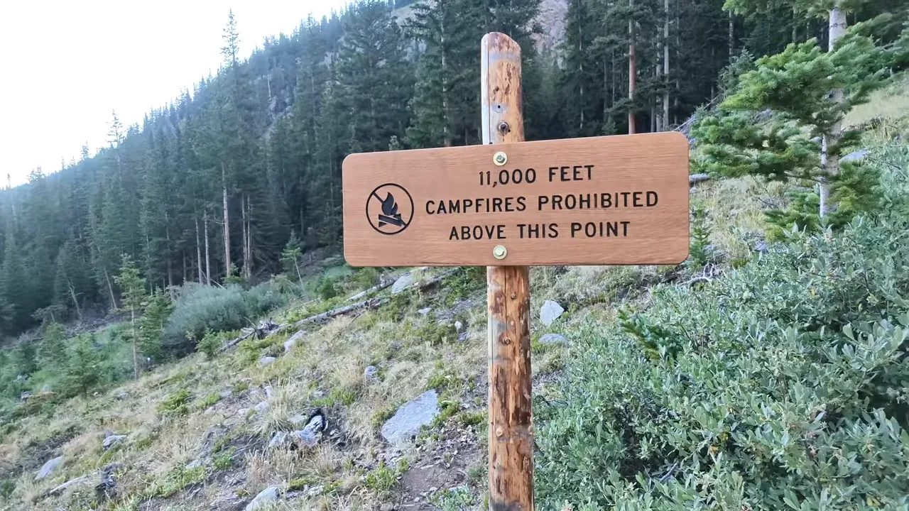
Farther along, I passed a sign marking 11,000 feet and stating that campfires were prohibited above that point. I hadn’t encountered that restriction before, and it caught my attention. It was a posted rule for this area, not something I could assume applied identically to every mountain.
I also had a mountain lion story in the back of my mind. A few weeks earlier, while hiking Mount Yale, I met someone who said he had camped near Missouri Mountain and found a mountain lion near the edge of his campsite in the morning.
He told me it wasn’t aggressive, but that it followed him as he packed up and headed toward the trailhead. I had also read accounts of encounters in the area. Those were other people’s reports, not something I experienced myself, but they definitely had me paying attention.
I didn’t see a mountain lion on my hike. Still, that story would be enough to make anybody a little nervous walking through the trees.
Breaking Out of the Trees Into Missouri Gulch
Near the upper forest, I noticed a few backpackers’ tents, with people camped farther off the trail. Then the trees began opening up, and the surrounding peaks came into view.
There’s something about reaching treeline that makes the effort feel real. You know you’ve made progress, even when the mountain makes it very clear that you still have a ways to go.
After those steep opening switchbacks, the more open gulch was a reward. The trail eased off, the creek ran nearby, and the mountain scenery was incredible. This was a chance to catch my breath and actually enjoy where I was instead of focusing only on the next uphill step.
The Wrong Turn: Follow Elkhead Pass at the Belford Junction
Then I managed to turn a nice stretch of hiking into extra work.
At a junction, I saw a sign pointing toward Elkhead Pass. My thinking was pretty simple: I wasn’t going to Elkhead Pass, I was going to Missouri Mountain. So I took the other branch, expecting Missouri to be named explicitly.
That was the mistake.
I noticed that some hikers behind me, who had also said they were heading for Missouri Mountain, took the Elkhead Pass branch. That was enough to make me stop and check Gaia GPS.
Sure enough, I was going the wrong way. I needed the right-hand branch toward Elkhead Pass, not the left-hand route toward Belford.
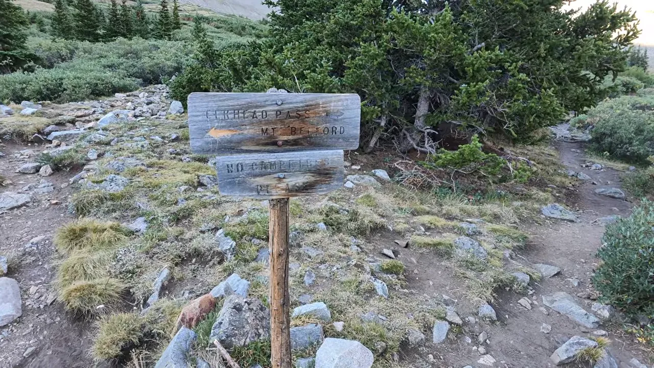
Thankfully, I caught it without losing a ton of time. Better to realize it here than much farther up Belford. Still, wasting energy and adding distance to a 4,500-foot climb isn’t my preferred warm-up.
Don’t make the same assumption I did: take the Elkhead Pass branch at this junction, then continue following your Missouri Mountain route. That doesn’t mean your destination is Elkhead Pass. It means the route initially shares that direction.
The sign alone didn’t match what I expected, but checking my position against the mapped route cleared things up quickly.
Through the Meadow and Up to the Saddle
Back on the correct route, I continued through the open basin. The meadow wasn’t particularly steep, and it gave me another welcome chance to settle into a comfortable pace.
From below, I could make out the saddle and ridge that I needed to reach, with what I believed was the summit farther along. Seeing the general shape of the climb helped, even if it also showed just how much uphill remained.
I encountered another sign farther up that appeared to have fallen from its post. Between that and my earlier mistake, I was glad I could check the route rather than depend entirely on signs.
Eventually, the easy meadow walking ended and the climbing started again. A series of switchbacks worked up the slope toward the saddle. I still felt pretty good, even after my detour, but this section made me earn the elevation.
Reaching the saddle was a big milestone. The views opened up beautifully, but I wasn’t on the main ridgeline yet. There was another steep section ahead, climbing up and around the rocky terrain.
The Ridgeline Still Has Work Left
Once I reached the ridge, I could see the summit in the distance. It was encouraging, but the climb wasn’t finished. There was still ridge travel and more elevation to gain.
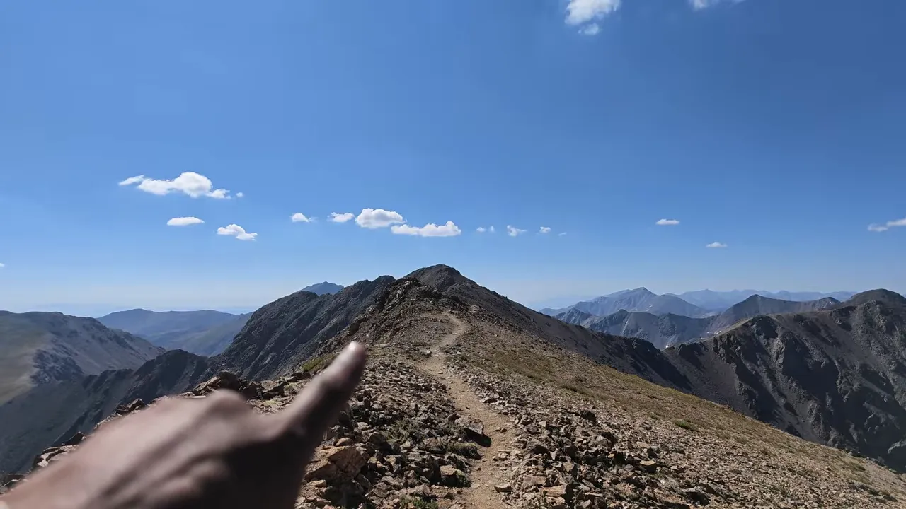
For most of the hike, the trail itself was reasonably straightforward to follow. The main navigation problem had been my choice at the signed junction, not repeatedly losing the trail.
Near the final approach, though, the terrain deserved more attention. The path dropped toward a rocky notch, and I put the camera away so I could use my hands.
The loose path beside the notch
There was a dirt line heading toward the right side of the notch that I didn’t like. The dirt was loose, and the slope was steep enough that slipping could turn into an unpleasant slide.
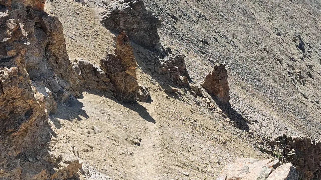
On the return, I stayed closer to the rocks and went between the rock features at the notch. I preferred that line much more than the loose dirt beside it.
That’s a personal observation from this trip, not a reason to treat the section casually. Slow down, assess the footing, and keep your hands available where you need them. The most obvious dirt track wasn’t necessarily the line that felt best to me.
Missouri Mountain Summit: Tough Climbs, Worthwhile Rewards
I made it to the summit, and it felt good to look back down into the gulch and see how far I had come.
Missouri Mountain wasn’t the toughest 14er I had climbed, but it wasn’t an easy stroll either. The forest switchbacks hit hard at the start, and the switchbacks below the ridge were another demanding stretch. The notch near the summit also required care with footing.
What made the day work was the balance: tough climbing, then a flatter stretch to recover; more climbing, then another incredible view. Add a comfortable campsite beside Clear Creek, and this turned into a really enjoyable mountain trip.
My biggest takeaway is simple. Bring route information you can check, and don’t assume every junction will name your summit exactly the way you expect. I wanted Missouri Mountain, dismissed the Elkhead Pass sign, and briefly put myself on the wrong mountain’s route.
At least I caught it early. Next time, I’d rather save that extra energy for the climb I actually came to do.